The Evolution Basin is one of the most beautiful areas in California. Several 13,000 foot mountains hold sublime glacial lakes and high alpine meadows. As if aware of this, nature jealously guards the area, with there being no easy and short approaches to the basin.
As with many of the places on the John Muir Trail, my first experience with the Evolution Basin was in August 2014. It had been a boring few days and I was glad to finally enter Sequoia and Kings Canyon National Parks, the true High Sierra, to sunny weather and clear skies. The fact that I was carrying 21kgs on my pack after a fresh resupply was sure as hell not going to ruin my day. That weight did prevent me from really exploring the area though. So I went back almost exactly a year later, with a lighter pack and a little more gumption.
Peter Croft’s Evolution Traverse has made the region legendary amongst climbers and the southern peaks hold several reasonable routes that don’t need a rope, even for mere mortals. I had permits (and time) for 4 days. Two days would be spent getting in and out. I was hoping to climb the easier Spencer, Haeckel, Wallace, Fiske, Huxley and Warlow in the other 2 days. Lofty goals for a stripling.
The ideal entrance to the Evolution basin is over Lamarck Col, a high mountain pass (just shy of 13,000ft) that is 6 miles and 4000ft from the North Lake trailhead. Unfortunately getting to even Mt. Spencer, the nearest peak, from Lamarck Col is another 6 miles of not so great trail.
Instead, I was looking to cross the Sierra crest 1 near the Haeckel-Wallace area and return similarly. Unfortunately there wasn’t any encouraging beta 2 about Haeckel Col, Haeckel-Wallace Col or Wallace Col and I would be winging it. We would start from Sabrina Lake, camp near Echo Lake, climb Wallace and Haeckel and descend to the west. We would setup camp there, day hike Warlow, Fiske and Huxley the next day, then hike out over Haeckel Col the next day. Such was the plan.
Routes form on maps based on history, story and ambition. They are traveled with skill, and change due to humility.
Lohit and Jeff were kind enough to take 2 days off from work to join me. We barreled across California late on Thursday night and made it east of Tioga pass before sleeping in a flat spot by the road around 1am. Thunder and lightning had followed us from the Bay to Yosemite. Fortunately these would stay away for the trip. After a quick breakfast at the Mobil station, we finished the drive to Bishop, picked up our permits and drove to the Sabrina Lake trailhead. We started hiking around 11am.
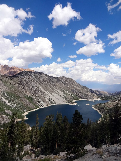
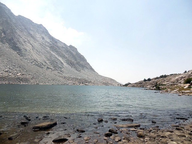
The ascent to Sailor Lake is on trail and fairly uneventful. The views are spectacular though.
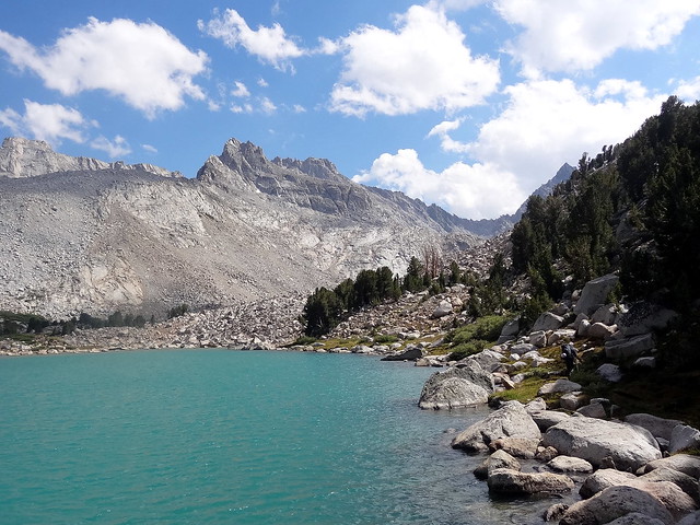
At Sailor Lake go up the rock pile to the south to reach Moonlight Lake. Moonlight is an incredible shade of glacial blue. From here the walking is exclusively on talus as you follow the inlet of the lake uphill. There are several places to camp between here and Echo Lake, the last campsites on this side of the crest.
Even with Lohit and Jeff feeling the altitude, we were at camp by about 4pm.
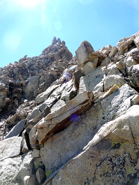
The next day we were on the trail by 7:30am. Follow Echo creek and stay right when the grade gets steep. Head to the slab and grass ledges towards Picture Peak to get above the steep banks of Echo Lake. Once at the ledges (around 12000ft), try to maintain elevation while traversing north into the Haeckel-Wallace drainage. From this point it is a compromise between route-finding, quality of talus and descending to the center of the drainage. The traverse is class 2 on refrigerator sized talus with occasional class 3 moves on solid rock.
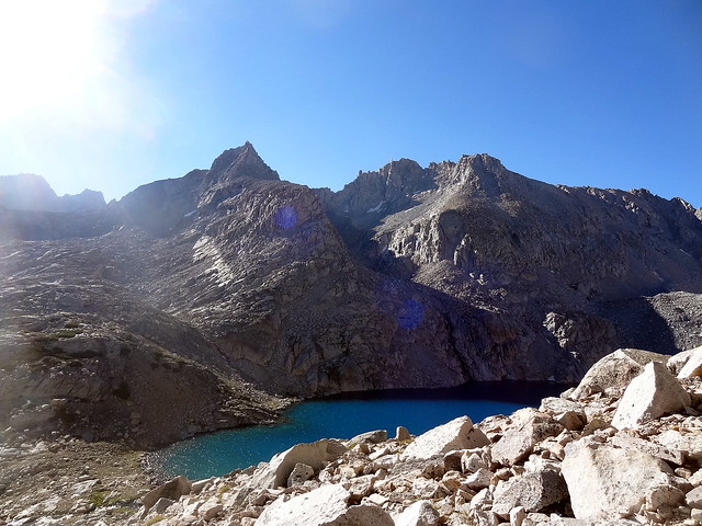
Once in the center, simply follow the creek up to “Haeckel-Wallace Lake”. I highly recommend filling up water from the creek, since the lake itself is hard to access due to talus.
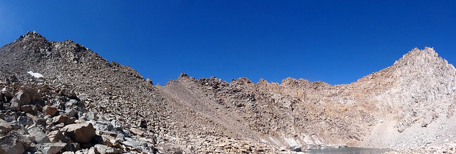
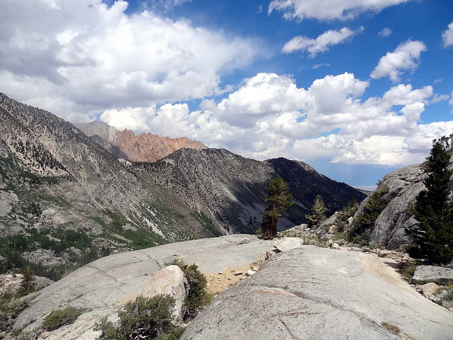
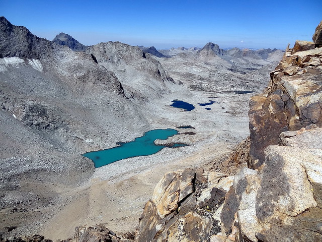
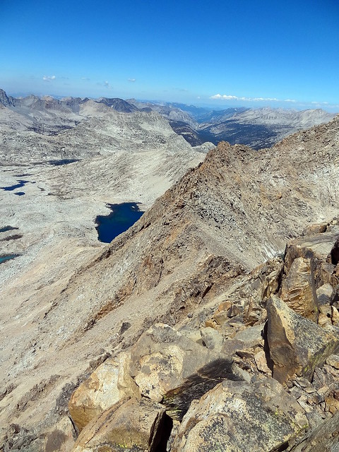
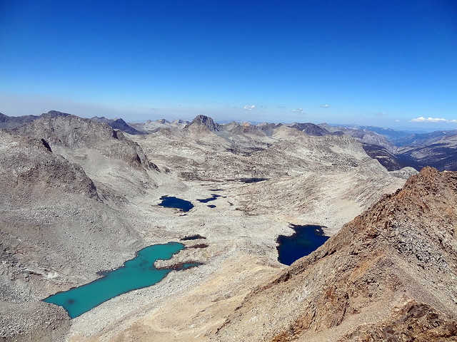
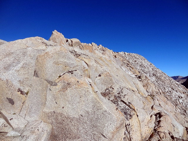
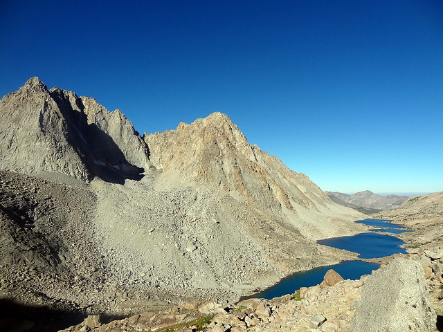
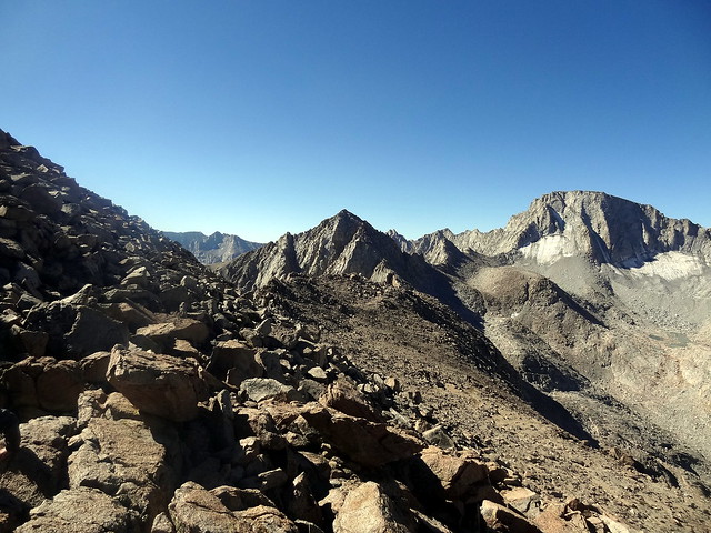
We headed up Wallace a little before 11am. Not having much beta except “north slopes are class 2”, we headed up the reasonable looking chute. While the right side of the chute presents a solid route to the top, it is definitely class 3 and higher, if you are comfortable on scree but don’t like exposure, going to the left of the snow patch is a better idea. Take the path of least resistance to gain the ridge. Fantastic views open up into the Evolution region. The peaks of the Ionian Basin and lesser known parts of Kings Canyon National Park open up in the west. Mt. Goddard, peeking out between Fiske and Huxley, and Mt. McGee, right of Huxley, dominate the landscape.
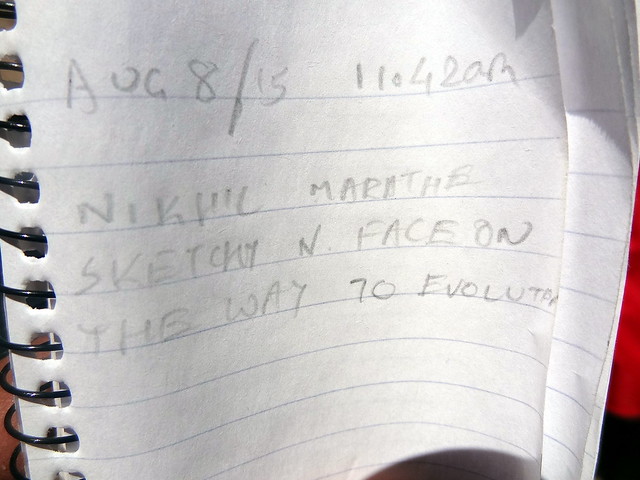
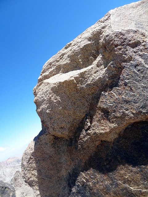
Jeff and Lohit decided to wait below the ridge since they weren’t too keen on class 4 climbing with packs on. I headed towards the summit of Wallace. The climbing is spicier on the ridge and easier if you drop east. I stayed fairly close to the ridge until right below the (false) summit, then crossed the chute to the biggest solid headwall on the left in the picture below. Great scrambling leads to a safe notch right below the true summit block. The summit register is located here. The summit block itself is a slim rectangle standing on edge. You can lieback on the left (north) side, mantle and pull yourself onto the broad area.
It felt great to be on the summit after fairly sustained climbing. The views were awesome, the location was remote and the weather was good. I only spent a few seconds on the summit block before getting spooked by exposure. A reasonable west side descent route was visible from the summit (Wallace-Haeckel col) and I figured we would head for it. Not wanting to downclimb the route I had taken, I chose another way just north of the summit block where you can drop down into an alcove then exit onto the scree slope.
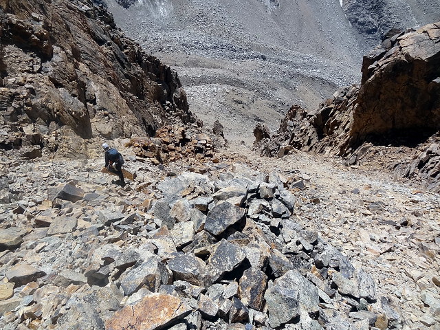
From here it was a treacherous descent to join up with Lohit and Jeff about halfway down Wallace. We then traversed left and headed up a reasonable looking chute. It wasn’t the chute we were looking for, as we found out on top. We figured we might as well take our chances on the west side since going down east looked just as bad, if not as sustained. So we spread out really far apart for possibly the most dangerous hour I have ever spent in the mountains. I hate scree, I would rather downclimb class 4 solid rock any day, and this slope was as unsettled as you could get, with huge rockfall danger. Jeff went first and I followed once he was about a hundred metres downchute. He chose the right side, so I went as left as I could and tried to find solid rock whenever possible. Even then, I did manage to almost kill him, sending a bowling ball sized rock down that narrowly missed his leg. Fortunately Lohit was going slow and I only had to deal with the rocks I was dislodging myself.
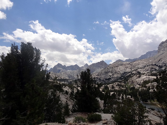
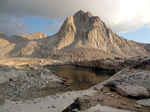
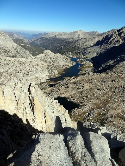
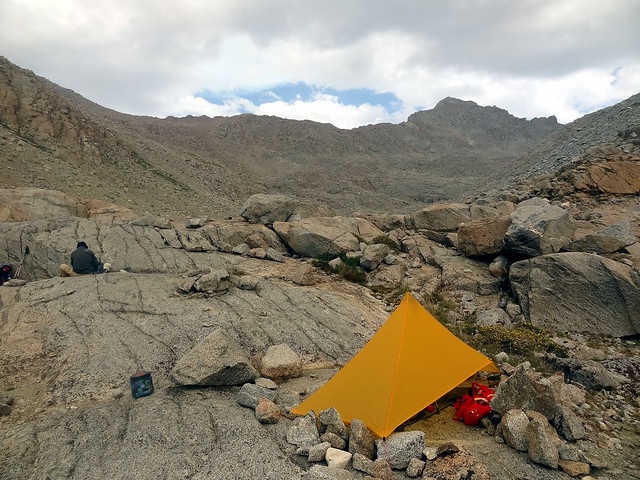
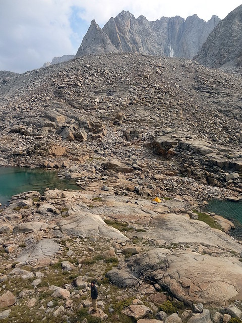
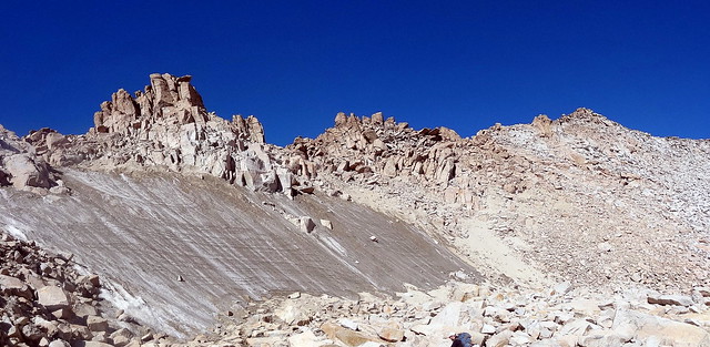
Jeff and I scree-skied the last quarter of the descent and reached the lake right below Fiske. After being on the edge and dehydrated, finding a giant rock to rest on eased fraying nerves. The 30 minutes we spent waiting for Lohit were well used in airing out shoes and socks. We dropped to the first lake, filled up on cool, clear water and continued to the second lake. There didn’t seem to be a reasonable path to Haeckel Col though several online posts had indicated it was viable and fairly easy 3. We decided that we had had enough adventure for this trip and heading out over Lamarck Col would be safer. This alpine basin is a stark contrast of gentle slabs and meadows and warmth amongst the imposing peaks. We set up camp at a small north-south oriented lake in that basin, just north of Huxley.
The next morning, Jeff and I headed out to Mt. Spencer. Getting to Spencer’s ridge is a beautiful walk up grassy slabs and we were up in no time. I was starting to feel a nagging pain in my left lung on uphills though and although I didn’t make a big deal out of it, I was worried if it would manifest badly.
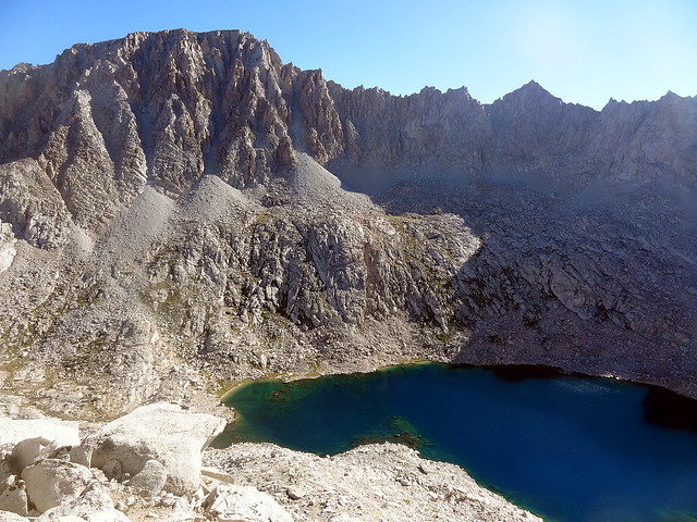
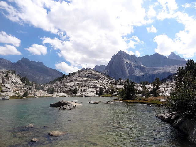
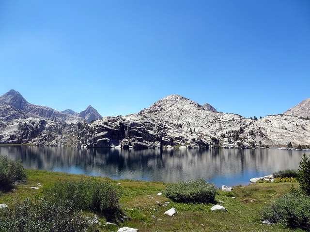
As you reach the wide platform east of the ridge, the beautiful lake between Darwin and Spencer comes into view. Despite all my pouring over maps, I had never paid much attention to this lake, and it was a stunning surprise. Once at the eastern base of the ridge, follow use trails for a bit until you encounter a big headwall that is class 5 by any measure. Here the trail seems to go both ways, and on climber’s right you can see several use trails down below on the face. We wasted some time and several of my ‘life units’ for the day trying to find a class 2 route but being forced to downclimb class 4 terrain instead. Eventually we gave up and returned to the starting point. Jeff bowed out, but I wanted to give it another shot.
This time I went up the class 3 terrain immediately right of the headwall. Gaining the ridge as soon as you could on this solid rock was the key. From here it is a wide and quick traverse to the summit that took only 10 minutes. After a quick snack while enjoying the views up and down the Evolution valley, I reversed the route and caught up with Jeff. We raced down to Lohit, packed up and headed down to Sapphire Lake to join the John Muir Trail.
Skirting east of Sapphire Lake we descending great slabs to the shore then followed the lake to the North and got on trail. After being on talus for several miles, our legs made easy work of the well groomed trail. We hopped across Evolution Creek and made really good time to Evolution Lake.
At about 10,700ft, just before the JMT starts switchbacking, you’ll notice a use-trail heading up and right. This is the way to Lamarck Col. The climb starts off incredibly steep and while the pain in my lung hadn’t increased, I kept running out of breath. We finally collapsed on to a rock at the Darwin Benches about 12:30. There was a bear bag hanging here, but no tent. The trail eases up and heads into Darwin Canyon before becoming just a series of cairns around the first and second lakes. I was on a short fuse at this point due to fatigue. When it looked like the trail was going to get better, I stopped and went through a quarter of a summer sausage and a couple of bagels to improve the situation.
At the third lake we met a guy setting out to attempt the Evolution Traverse. We figured the earlier bear bag was from another intrepid adventurer. Using the time to talk to him to fill up water, we followed the trail around the lake to the fourth lake. Here there are several bivy sites. Various vague trails up to Lamarck Col appear across the lake. The guy told us there were no campsites beyond this so we set up shelter even though it was only 4pm.
I felt good about having an opportunity for a longer rest day. Jeff and Lohit were hoping to cross the Col today, but it didn’t seem worth the exhaustion when we could attack it well rested. Instead, we spent the time relaxing and clambering around some boulders as Mendel kept us company.
As I lounged around, I realized I wasn’t actually looking forward for the trip to end. I hadn’t felt this content in the backcountry at any time after the JMT. Sure, we had had our asses kicked, but down here in the valley the weather was good, the lakes were wonderful and I had no responsibilities or worries.
This was perhaps the trip on which I felt most at home in the backcountry.
While the water was boiling another pair passed us and continued to the benches. I only point this out because one of them had a pack I lust after, but don’t really want.
After an early dinner I sat down with Skyfaring as the Earth turned and sunset was imminent. Jeff and Lohit went to bed. While having dinner we had noticed two specks descending Lamarck Col who were moving very slowly. When reached the talus field at the fourth lake, I realized they had mega-gigantic-humongous packs and were clearly not doing well. I quickly reached them to find a teenage girl and her mom looking beat. As soon as I took the mom’s pack I realized why they were struggling. It must have easily been 50lbs. I dragged it back to camp and woke up Jeff to get some water boiling. The two were on a 7 day Lamarck Col to Bishop Pass trip but it had already taken them 2 days to reach here and I wasn’t sure how they would make it in time. Out came fresh herbs and fancy food and I had to bite my tongue. I try to follow a school of thought that emphasizes speed and safety over comfort. Philosophical differences I guess. We handed them one of our fuel canisters and turned in for the night.
The next day we headed up Lamarck Col. There are hundreds of permutations of trails, just pick one that works. I tried to go as straight as I could, taking breaks so my lung wouldn’t stab me. Jeff and I made the Col in 2.5 hours. Lohit had a horrible headache (due to not eating enough on the trip) and was far behind. I took the time to scramble towards Mt. Lamarck, but was cut of by some gendarmes.
Once Lohit was at the top and we were sure he wasn’t dying from altitude, we descended the sharp switchbacks on the east, drank some silty water from the Lamarck glacier (the small lake at 12,700’ no longer exists) and barged down the sandy trail.
Some trips just heap on adventure after adventure and we were on one of them. We managed to lose the trail and ended up in the drainage south of the Lamarck Lakes. Just when things were supposed to improve, we were instead treated to horrible talus, followed by bushwhacking. We hoped Lohit hadn’t lost the trail and followed us! Eventually Jeff and I got lucky and stumbled upon an abandoned trail that led down to Grass Lake.
We could finally relax as the parking lot came into view. We walked another mile before a friendly car gave Jeff a ride to Lake Sabrina. He was back in twenty minutes and we drove to the trailhead to wait for Lohit. After an hour Lohit tumbled out from a completely different direction. Turns out he had followed us on the horrible talus, then found his own way down.
The adrenalin of the last several days was keeping me awake, so I volunteered to drive us down to Bishop, where the inside of Schat’s bakkery lifted us out of exhaustion. Bacon cheese chilli bread is the pinnacle of civilization at such times! We then drove down to the roadhouse for incredible burgers before beginning the long drive home.
The Sierra Nevada run north to south forming the backbone of California. The mountains rise gradually on the west, but very sharply on the east. This makes access from the east easier, but requires crossing the crest to get to various places.
[return]A climbing term for prior information about the area obtained from other climbers.
[return]- Turns out the route is easy, if you know where to look [return]